My research on Map Generalisation
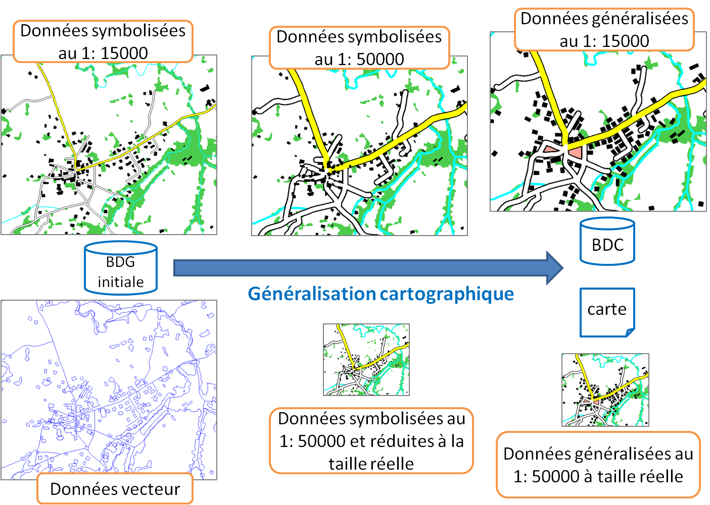
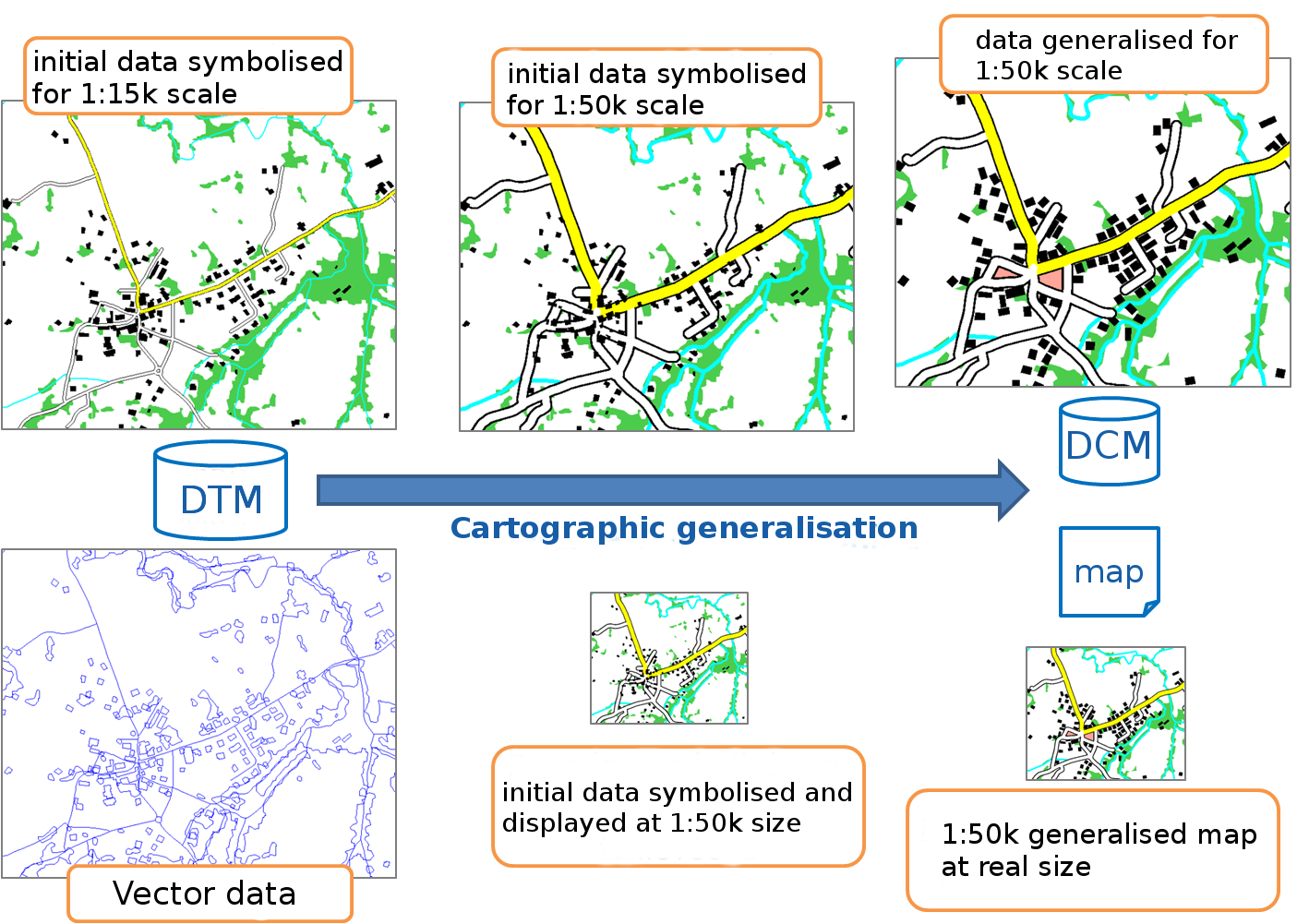
Map generalization has been my main research field since my arrival at IGN in 2004. Map generalization is the process that simplifies map features (roads, buildings, rivers, forests...) when scales decreases that keep them legible for the map reader. Just like text summarization, map generalization simplifies the content of the map while preserving the main characteristics of the geographic features depicted in the map.
La généralisation cartographique est mon sujet de recherche principal depuis mon arrivée à l'IGN en 2004. La généralisation cartographique est le processus qui simplifie les objets d'une carte (route, bâtiment, rivière, limite administrative...) quand l'échelle de la carte diminue, pour garder ces objets lisibles pour le lecteur de la carte. A la manière d'un résumé de texte, la généralisation cartographique simplifie le contenu de la carte tout en préservant au mieux les caractéristiques principales des entités geographiques représentées dans la carte.
Generalisation Algorithms
Algorithmes de généralisation
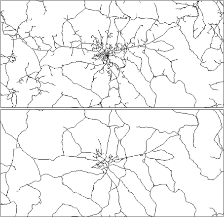
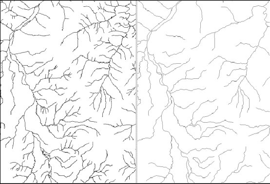
Generalisation algorithms are the building blocks of an automated generalisation process. They transform the geometry of one or several map features. Generalisation algorithms can simplify, aggregate, enlarge, displace, caricature or typify map features, see this chapter to learn more on the existing algorithms.
Generalisation algorithms are the building blocks of an automated generalisation process. They transform the geometry of one or several map features. Les algorithmes de généralisation peuvent simplifier, agréger, grossir, déplacer, caricaturer ou typifier les objets de la carte, voir ce chapitre pour en savoir plus sur tous les algorithmes existant.
Generalisation Orchestration
Orchestration de la généralisation
Generalisation processes seek to automate the application of several algorithms on different map features to generalise a part or the totality of the map. Generalisation processes make automated decision on the orchestration of the algorithms: which algorithm to use, on what map features, with what parameters?
Un processus de généralisation cherche à appliquer automatiquement le bon algorithme aux différents objets de la carte pour la généraliser en partie ou totalement. Les processus de généralisation prennent de manière automatique des décisions sur l'orchestration des algorithmes: quel algorithme ? sur quels objets ? avec quels paramètres ?
CollaGen model
Modèle CollaGen
While generalization processes such as AGENT, or CartACom, orchestrate the use of generalization algorithms, CollaGen goes one step upper in the generalization orchestration by orchestrating the use of generalization processes on different parts of the map, in order to fully generalize a complete map. CollaGen was mainly developed during my PhD.
Alors que les processus de généralisation comme AGENT, ou CartACom, orchestrent l'application des algorithmes sur différents objets, le modèle CollaGen monte d'un niveau dans l'orchestration en orchestrant l'utilisation des processus de généralisation comme AGENT ou CartACom sur différentes parties de la carte, afin de la généraliser complètement. CollaGen a été essentiellement développé pendant ma thèse.
- Touya, Guillaume. CollaGen: Collaboration between Automatic Cartographic Generalisation Processes. In Proceedings of 12th ICA Workshop on Generalisation and Multiple Representation, Zurich, Switzerland, 2010.

- Touya, Guillaume, Cécile Duchêne, and Anne Ruas. Collaborative Generalisation: Formalisation of Generalisation Knowledge to Orchestrate Different Cartographic Generalisation Processes. In Geographic Information Science, edited by Sara Fabrikant, Tumasch Reichenbacher, Marc van Kreveld, and Christoph Schlieder, 6292:264–278. Lecture Notes in Computer Science. Berlin, Heidelberg: Springer Berlin / Heidelberg, 2010.
- Touya, Guillaume, and Cécile Duchêne. CollaGen: Collaboration between Automatic Cartographic Generalisation Processes. In Advances in Cartography and GIScience, edited by Anne Ruas, 1:541–558. Lecture Notes in Geoinformation and Cartography. Berlin, Heidelberg: Springer Berlin Heidelberg, 2011.
ScaleMaster2.0
The ScaleMaster framework was first proposed by Brewer & Buttenfield (2007). It allows the specification of multi-scale maps in a graph similar to a timeline where scale replaces time. Further experiments on multi-scale maps design with the ScaleMaster were presented by Brewer & Buttenfield (2009). The ScaleMaster2.0 is updated version of the ScaleMaster dedicated to automated generalization based on the rules of a ScaleMaster. It was proposed by Touya & Girres (2013)
Le concept du ScaleMaster a été proposé initialement par Brewer & Buttenfield (2007) Ce modèle permet de définir les spécifications de cartes multi-échelles dans un graphique similaire à une frise où l'échelle remplacerait le temps. Plusieurs expériences de conception de cartes multi-échelles avec ce ScaleMaster sont présentées dans Brewer & Buttenfield (2009). Le ScaleMaster2.0 est une extension du ScaleMaster qui permet de déclencher des généralisations automatiques à partir des spécifications définies dans le ScaleMaster. Le modèle a été proposé dans Touya & Girres (2013)
Evaluation of map generalisation
Evaluation de la généralisation cartographique
Global evaluation with social welfare techniques
Evaluation globale inspirée par la mesure du bien-être social
Clutter based evaluation
Evaluation par mesure de l'effet de Clutter
Generalisation tools
Generalisation tools developed in LASTIG in the past years
Outils logiciels
Historique des outils logiciels développés au LASTIG
-
10-09-2004
LAMPS2 (LaserScan)
LAMPS2 was a generalisation software developed by the UK company 1Spatial (called Laserscan at that time). LAMPS2 contained the results of the EU funded AGENT project, and many of the past results on map generalisation from COGIT team were included in the software.
LAMPS2 était un lgiciel de généralisation développé par la société britannique 1Spatial (qui s'appelait Laserscan à l'époque). LAMPS2 contenait les résultats du projet européen AGENT, ce qui incluait une grande partie des résultats passés de l'équipe COGIT en généralisation.
-
01-01-2006
Clarity (1Spatial)
LAMPS2 becomes Clarity, and the plugins have to be coded in Java at this point, so we transfered our old LAMPS2 code into Java code, to be compatible with the new software.
Le logiciel LAMPS2 devient Clarity, et cette fois, les plugins construits autour du logiciel sont codés en Java, donc nous basculons une grande partie de notre code LAMPS2 en Java, pour qu'ils soient utilisables dans le nouveau logiciel.
-

01-01-2010
GeOxygene
In order to be compatible with the prototypes developed by other researchers in the COGIT research team, we abandoned our developments in Clarity to build a new research platform in Java from scratch. This platform is a plugin of the open source COGIT platform GeOxygene, but this generalisation plugin is not open source yet.
Afin d'être compatible avec les prototypes developpés par nos collègues de l'équipe COGIT, nous abandonnons Clarity pour construire une toute nouvelle plateforme en Java. Cette plateforme est un plugin de la bibliothèque libre GeOxygene du COGIT, mais ce plugin de généralisation n'est lui pas encore libre.
-

01-01-2017
CartAGen
CartAGen is an open research platform for map generalisation. Developed in Java, it derives from the GeOxygene platform plugin we were previously developing.
CartAGen est une plateforme de recherche libre pour la généralisation cartographique. Développée en Java, elle dérive du plugin de GeOxygene (non libre) sur lequel notre équipe travaillait avant.
-
01-07-2018
DeepMaGen
In parallel with CartAGen, DeepMapGen is a Python library for deep learning based map generalisation.
Parallèlement à CartAGen, DeepMapGen est une bibliothèque Python pour faire de la généralisation cartographique par apprentissage profond.
Publications
ICA Commission
Commission ACI
The commission on map generalisation and multiple representation of the International Cartographic Association (ICA) has been active since 1995. I started chairing the commission in 2017, my co-chairs are Paulo Raposo (ITC, Twente University, the Netherlands), and Pia Bereuter (FHNW University of Applied Sciences of Northwestern Switzerland). Follow the activities of the commission on its website.
La commission sur la généralisation cartographique et la représentation multiple de l'Association Cartographique Internationale (ACI) est active depuis 1995. J'ai commencé à piloter la commission en 2017, avec mes co-chairs Paulo Raposo (ITC, Twente University, Pays-Bas), et Pia Bereuter (FHNW University of Applied Sciences of Northwestern Switzerland). Suivez les activités de la commission sur son site web.
Activities of the commission:
Ce que fait la commission:
- Organize workshops every year
- Edit books and journal special issues
- Foster collaborations between researchers on common topics (web services, or ontologies).
- Organisation d'au moins un atelier chaque année
- Edition de livres et de numéros spéciaux de journaux
- Initier des collaborations entre les chercheurs de la commission sur des sujets d'intérêt commun (services web, ou ontologies).