Azelle Courtial
PostDoc in LostInZoom project.
Member of the MEIG research team on the extraction, structuring, qualification and combination of geographic information.
PostDoc dans le projet LostInZoom .
Membre de l'équipe MEIG sur l'extraction, la structuration, la qualification et la combinaison de données géographiques.
Dissertation Work: ![]()
Travail de thèse: ![]()
News
1st Webinar of the ICA Commission on Multi-scale cartography.
I am invited to present an overview of my research on deep learning techniques for map generalisation.
1er Webinaire de la Commission ACI sur la cartographie multi-échelle.
Je suis invitée à présenter un aperçu de mes recherches sur les techniques d'apprentissage profond pour la généralisation de cartes.
Participation at GISciences 2023.
I presented a collective work "Text-to-map generation: an exploration of current potentials" at the CartoAI workshop; and
my work "Does Generalisation Matters in Pan-Scalar Maps?" at the main conference.
Participation à GISciences 2023.
J'ai présenté le travail collectif "Text-to-map generation: an exploration of current potentials" à l'atelier CartoAI et le travail "Does Generalisation Matters in Pan-Scalar Maps?" lors de la conference.
Thesis defense.
I defended my thesis entitled: "Exploring the potential of deep leanring for map generalization".
Soutenance de thèse.
J'ai soutenue ma thèse sur l'exploration du potentiel de l'apprentissage profond pour la généralisation cartographique.
Survey on evaluation of mountain road generalisation.
The results of the survey and of my experiment on mountain roads generalisation using GAN are published.
Sondage sur l'évaluation de la généralisation des routes de montagne.
Les résultats de l'enquête et de mon expérience sur la généralisation des routes de montagne à l'aide du GAN sont publiés.
Participation at AGILE Conference 2022.
I presented my work entitled "Representing Vector Geographic Information As a Tensor for Deep Learning Based Map Generalisation." and I got the award "best short paper".
Participation à la Conférence AGILE 2022.
J'ai présenté mon travail "Representing Vector Geographic Information As a Tensor for Deep Learning Based Map Generalisation." et j'ai obtenu le prix de meilleu papier court de la conférence.
Participation at IGN research day.
I will present my work entitled "Usage of vector spatial data in image-based deep learning models", the video recording is available here.
Participation à la journée de la recherche de l'IGN.
Je présenterais mon travail "Utilisation de données spatiales vectorielles dans les modèles d'apprentissage profond basés sur des images", l'enregistrement vidéo est disponible içi.
Participation at EGC conference.
I presented my work about representing and combining spatial data for deep learning at the workshop on spatial and temporal data managment and analysis.
Participation à la conférence EGC.
J'ai participé à l'atelier gestion et analyse de données spatio-temporelles de la conférences, j'y présente l'article : "Représentation et combinaison de l'information géographique pour l'apprentissage profond".
Participation at ICC 2021.
I presented my work titled "Can Graph Convolutional Network Learn Spatial Relations ?" during the conference.
I took part to the Pre-Conference Workshop 24th ICA Workshop on Map Generalisation and Multiple Representation and proposed A Benchmark for Deep Learning-Based Generalisation - AlpineBends.
Participation à la conférence ICC 2021.
J'ai présenté mon travail "Can Graph Convolutional Network Learn Spatial Relations ?".
J'ai participé à l'atelier Pre-Conference Workshop 24th ICA Workshop on Map Generalisation and Multiple Representation et j'ai proposé un benchmark pour la généralisation de routes de montagne - AlpineBends.
I took part to the Pre-Conference Workshop 24th ICA Workshop on Map Generalisation and Multiple Representation and proposed A Benchmark for Deep Learning-Based Generalisation - AlpineBends.
J'ai participé à l'atelier Pre-Conference Workshop 24th ICA Workshop on Map Generalisation and Multiple Representation et j'ai proposé un benchmark pour la généralisation de routes de montagne - AlpineBends.
Survey on evaluation of mountain road generalisation.
The survey is now closed, thank you for your participation. The results will be includ in a future publication.
Sondage sur l'évaluation de la généralisation des routes de montagne.
L'enquete est maintenant terminée, merci de votre participation. Les resultat seront inclus dans une future publication.
Research Interests
Sujets de recherche
Map generalization
Généralisation cartographique
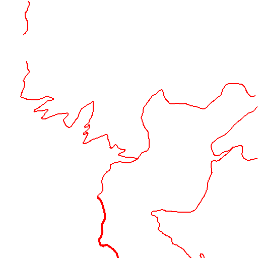

La généralisation cartographique correspond à l'adaptation d'un jeu de données géographiques détaillées pour réaliser une carte à plus petite échelle. Le changement d'échelle implique la diminution de l'espace disponible, il est alors nécessaire de simplifier ou sélectionner l'information géographique représentée. L'automatisation de la généralisation cartographique est un sujet de recherche important, il existe de nombreux operateurs de généralisation et des méthodes d'orchestration de ces algorithmes, l'automatisation complète de ces processus n'est cepandant pas encore possible.
Map generalisation is the adaptation of a set of detailed geographical data to produce a map at a smaller scale. The change of scale involves a reduction of the available space, it is then necessary to simplify or select the geographical information presented. The automation of cartographic generalization is an important research subject, and despite many generalization operators and methods of orchestration, complete automation has not yet been achieved.
Deep learning
Apprentissage profond
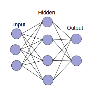
L'apprentissage profond fait partie des techniques d'intelligence artificielle dont le but est d'apprendre à résoudre une tâche de gestion de données à partir d'exemples. Le model est d'abord défini avec une certaine architecture et des poids aléatoires, puis il est appliqué aux données du jeu d'entrainement. La comparaison de la prediction avec le resultat attendu permet d'optimiser les poids du model. Le processus est répété jusqu'à obtenir uns stabilisation et/ou un résultat satisfaisant.
Deep learning techniques belong to artificial intelligence technics that aims to learn to solve data management task from examples. The model is first defined with a specific architecture and random weights, then it is applied to training data. The predictions are compared with the expected results in order to optimize the model's weights. This process is repeated until obtaining steady and correct results.
Multi-scale maps
Cartes multi-scalaires
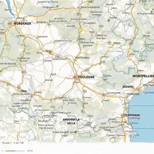
De nos jours, les carte interactives incluant plusieurs representation à diverses échelle sont les plus répendues et utilisées. Ces cartes induisent des usages et besoins differents des cartes topographiques papiers. Ainsi, il est important de comprendre comment les utilisateurs interagissent avec la carte pour adpater la represenation pour faciliter la naviguation, à la fois spatiale (horizontale) et entre les échelles (verticale).
Nowadays, maps are mostly interactive and include multiple representations at several scales. Multi-scale maps lead to new usages and requirements compared to printed topographic maps. Thus, it is important to understand how users interact with such maps in order to adapt representation and facilitate navigation both spacially (during pan), and between scales (during zoom in and out).
Projects
Projets
Education
Université Paris-Est
Université Paris-Est, ENSG
Université Paris 7-Diderot
Publications
Ressources
Slides
Exploring the potential of deep learning for map generalization
Slides for my thesis defense, January 2023.
Presentation at AGILE June 2022 conference. Best short paper award.
Videos
Posters
Apprendre à combiner l'information géographique pour générer une carte généralisée
Poster pour la conférence francophone sur l'extraction et la gestion des connaissances, January 2022.
Poster pour l'atelier GAST de la conférence francophone sur l'extraction et la gestion des connaissances, Janvier 2022.
Apprendre à générer des extraits de carte généralisée d'espaces urbains
Poster pour les journées de la recherche de l'IGN, Mai 2021.
Généralisation des routes de montagne par apprentissage profond
Poster pour les journées de la recherche de l'IGN, Octobre 2020, Généralisation des routes de montagne par apprentissage profond.
Videos
Other research activities
CartAGen4Py
Python port of the CartAGen library for map generalization.
DeepMapGen
Python library for deep learning based map generalisation.
Teaching
Enseignement
| Subject | Public | Year | Hours | Class size | Nature | Supplementary responsibility |
| Spatial databases - Postgis | Ingeneer 2nd year | 2023 | 15 | 30 | Tutorial | |
| Webmapping | Ingeneer 2nd year | 2023 | 9 | 8 | Project | Subject creation Supervision Assessment |
| Spatial analysis | Ingeneer 2nd year Master 1 | 2022 2021 | 9 | 30 | Tutorial | |
| Introduction to programming - Python | Licence 1 | 2021 2020 | 40 | 20 | Lectures Tutorial | Updating course material Exam creation and assessment/td> |
| Cartography and database project | Licence 3 | 2020 | 18 | 15 | Project | Supervision Assessment |
| Introduction to GIS | Master 1 | 2021 2020 2019 | 18 | 15 | Tutorial | Updating course material Exam creation and assessment |
| Matière | Public | Année | Heures | Effectif | Nature | Responsibilités supplémentaires |
| Base de données spatiales - Postgis | Ingenieur 2eme année | 2023 | 15 | 30 | Travaux pratiques | |
| Webmapping | Ingenieur 2eme année | 2023 | 9 | 8 | Projets | Creation de sujets Supervision Evaluation |
| Analyse spatiale | Ingenieur 2eme année Master 1 | 2022 2021 | 9 | 30 | Travaux pratiques | |
| Introduction à la programmation - Python | Licence 1 | 2021 2020 | 40 | 20 | Cours Travaux pratiques | Mise à jours du support de cours création d'exercices et évaluation |
| Projets cartographie et base de données | Licence 3 | 2020 | 18 | 15 | Projets | Supervision Evaluation |
| Introduction aux SIG | Master 1 | 2021 2020 2019 | 18 | 15 | Travaux pratiques | Mise à jours de support de cours, création d'exercices et évaluation |